
The Alps have been a barrier for more than just pilgrims and travellers. It has sometimes been an almost insurmountable barrier for armies – Hannibal, Caesar, Charlemagne and Napolean all had great difficulties moving their armies between Gaul and Italy. Although to the Romans the Alps was a barrier between two Gauls - Italia formally did not start until the Rubicon river, Northern Italy was known as Cisalpine Gaul, and the area on the other side of the Alps was known as Transalpine Gaul. It was not until the reign of Augustus that Italia was expanded to include all the territory up to the Alps, old Cisalpine Gaul. Another Roman anomaly for the Alps was that for a long time after Caesar conquered Gaul, the Alps remained ruled by independent territories allied to Rome but not formally governed by Rome. There were a number of different passes through the Alps – the Via Francigena goes through Great St Bernard‘s Pass, between Switzerland and Italy.
As we ascend sharply out of Besancon the reality that we are heading for mountainous territory starts to hit home. I have dreaded this stage since Matthew first floated the idea of this walk, now I’ll see if it really is possible.
“Walk over the Alps? You must be joking!” I recall saying. It was the major sticking point for me, and I’m sure I’m not alone there.
Happily the Via path plateaus after the exhausting climb and we walk up a small section of Roman road as we catch our breath and drink some water. We walk on through forests and search out a couple of dolmens just before Ornans.
Our path, quite logically really, jumps from river valley to river valley and the valley of the Loue River is quite spectacular. The villages en route are quite lovely, bridges crossing burbling water, flower boxes on the parapets, cafes alongside … the valley becoming smaller and narrower and steeper as we rise towards the source.
We see no elephants, but shrews, goats, donkeys, horses, sleepy cats and soaring raptors abound. They really are so majestic, flying on high. We picnic on grassy hills nibbling local cheeses on slabs of fresh bread. On our last day in France we fall asleep to the sound of Bastille Day fireworks.
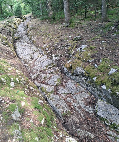
As we cross the border into Switzerland we are slightly underwhelmed, there is just an unmanned hut. Soon though we see Swiss flags proudly flying and cowbells fill the air, joining the regular peal of church bells. We come across a superb section of Roman road with a dedicated local volunteer clearing leaves and debris from the deep wheel ruts (see Figure 1). Spurred on with wonder we go on to enjoy magnificent Roman mosaics (deserted in the heat) at Orbe until, hot and footsore, we head to the local pool to escape the heat and enjoy their poolside restaurant. Such culture vultures!
We reach Lausanne via an avenue of trees which lead us straight to the shores of Lake Geneva – in we go! An icy cold swim? No, a delightfully refreshing yet moderate temperature. We swim every day for the next week as we dally in Lausanne and walk around the delightful lake also known as Lac Leman. The museum has a nice collection, though small, and there are Roman ruins and a mosaic nearby.
Hannibal was one of the earliest documented and most famous crosser of the Alps. In 218 BC after a long march from Spain, he led his motley army (a collection of Carthaginian, Spanish and Celtic allies, which included elephants) over the Alps to invade Italy from the North. The Senate sent Publius Cornelius Scipio with an army to stop Hannibal’s advance. Scipio (father of the more famous Scipio Africanus) brought his army by boat to Transalpine Gaul only to find that he had missed Hannibal, who had already crossed the Rhone and was marching to the Alps. Scipio brought his army back to Cisalpine Gaul, prepared to meet Hannibal on his march back down the Alps. The Carthaginian general, even though his army was fatigued and depleted by the alpine marches, defeated the Roman army at the Ticinus river and wounded Scipio. It is argued which pass Hannibal used to cross the Alps, but it was probably not the Poenine (as Great St Bernard’s Pass was known to the Romans). Livy disputes the theory that the pass got its name from “Punic” because Hannibal crossed there - he believed that the pass got its name from a local deity called Poeninus (Livy 21.38).
Caesar, when given his governorship of both Cisalpine Gaul and Transalpine Gaul in 58 BC, had to move his army into Gaul over the Alps. The tribes that dwelt there gave his army some difficulties, but he came to terms with one of their leaders. He sent his legate Servius Sulpicius Galba (the great grandfather of the future emperor) to pacify the tribes of St Bernard’s Pass. Although Galba met with success at Martigny, he did not push his advantage.
Many centuries later, the Frankish king Charlemagne also had to cross the Alps with an army. The Pope had successfully appealed to his father Pepin the Short for help against the Lombards, the German tribe that occupied Northern Italy after the fall of the Roman Empire. When the Lombards were causing trouble again, the Pope relied on his Frankish alliance and called for Charlemagne’s aid. The Frankish king and his army probably did use Great St Bernard’s Pass, but not without difficulties as Charlemagne’s biographer Einhard chronicles:
“At this point I really should explain how difficult Charlemagne found the crossing of the Alps when he came to enter Italy, and after what effort on the part of the Franks the pathless ridges of the mountains were traversed, and the rocks which reared themselves up to the sky and the abrupt abysses…” (Einhard, ‘Life of Charlemagne’, 2.6)
The walk around the lake is just divine. Vineyards climb the hillsides, grapes ripened from the warmth of a trinity of direct sun, reflection from the lake and the stone terraces. We picnic on stone walls lakeside and enjoy the halcyon days.
All too soon, however, we take the narrow valley out and up towards the pass. We walk at the base of the valley and are again surrounded by mountains, but this time really big ones. We approach the sections of the path known as the most challenging and are a little wary but we have our GPX files, our eBook guide and the VF app... narrow paths with sheer drops don’t scare us!
Slight rain cools us down as we walk into the abbey of Saint Maurice (see Figure 3). It is hidden by mountain folds until the last minute, tucked away and built hard up against the rock. Unfortunately, the scavi is closed when we arrive, we will need to see that next time…
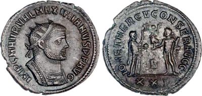
Our previous article mentioned some of the insurrections in Gaul during the Roman Empire. One of the later problems we did not mention was the uprising of the Bagaudae. This movement arose during the time of uncertainty after the Emperor Carinus denuded much of the troops of the Western Empire to face the usurper in the East, Diocletian. The Bagaudae were large, disorganised bands of mostly landless peasants that sprang up in Gaul during this period. Diocletian defeated Carinus but realised that the large empire faced too many problems to be solved by one emperor. He elevated a former colleague, Maximianus, as his co-Emperor (see Figure 2) and sent him West. One of Maximianus’ charges was the suppression of the Bagaudae.
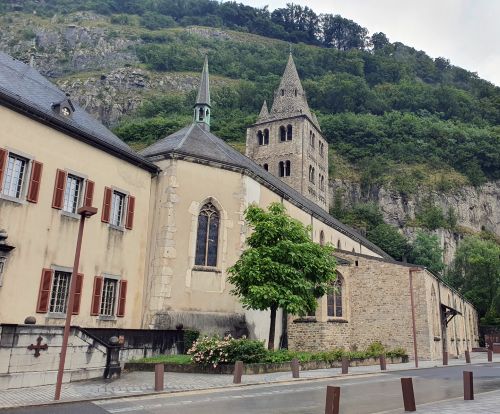
Christian tradition holds that one of the legions sent with Maximianus was from Thebes and it was commanded by Maurice, who was a Christian. This “Theban” legion was tasked with clearing the Alpine passes of Bagaudae. Before operations commenced, the legions were required to make sacrifices to the Roman gods and the Emperor. Maurice and his soldiers, as Christians, refused to do so and Maximianus ordered their decimation (one in every ten soldiers executed) as punishment. When Maurice and the legion still refused to comply, they were all executed and became martyrs. The abbey in the town now known as St Maurice, was built on the spot of their execution (see Figure 3).
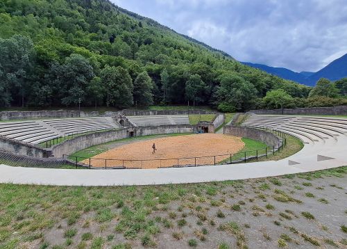
The Roman ruins at Martigny are all out in the open. Sitting in the shadow of a mountain, the amphitheatre (see Figure 4) is large and its structure is intact although the seating has been rebuilt. Various ruins are exposed in the grounds of the museum and a nearby children’s park includes wall foundations for a villa including latrines.
After Martigny we traverse the section commonly know as “the most difficult part of the Via Francigena”. I have seen so many facebook posts warning of this, and the subsequent boulder field where five different groups got lost on a single day. A little spooked, we decide to walk this bit without our full packs. A narrow and sometimes slightly treacherous path, I am greatly relieved once we are beyond Sembrancher, but Matthew takes it all in his stride. Onwards and upwards!
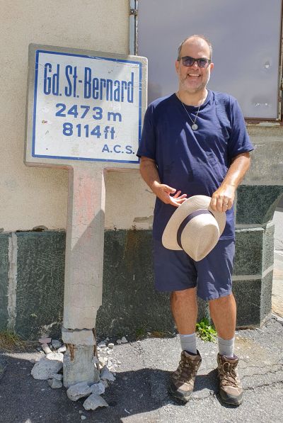
We climb steadily each day, just a gentle incline which is easily manageable until the last ascent to the Pass. Our path is peaceful, although we meet many others walking/hiking as the trails merge. The final day up to Saint Bernard’s pass does challenge the body but the relief and exaltation once the summit is reached is overwhelming (see Figure 5). It is a strange spot, a small cluster of buildings and a road surrounded by close mountains. We are at the top! I sleep well.
After a comfortable night’s rest in the Auberge de l’hospice we climb down the other side into Italy. Oh, the legs! The views are magnificent and it is amazing how much the scenery changes once we cross the lake/border to Italy. The mountainsides are a lot more barren and dry, with many rockfalls.
The Aosta valley captures my heart. I am in awe of the closeness of the mountains and the people who live in these narrow spans. We walk beside ever flowing water reminiscent of ancient aqueducts and I start to feel like I’m in Italy.
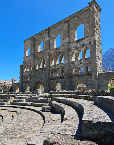
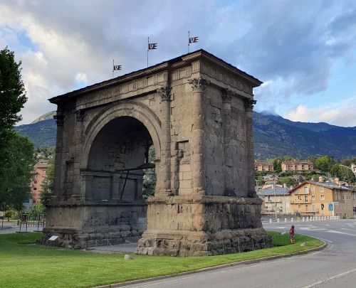
I love Aosta. Our apartment is on the 4 th floor and we hear rain on the slate roof tiles as we head off to sleep. The sounds of church bells and voices enjoying the long evenings… The Roman ruins in Aosta are really worth seeing. The theatre (see Figure 6) is the only one we’ve seen on this path, it is quite imposing with a single standing arched wall towering before the mountains and I am excited that we can see it from our flat. We leave via the Arch of Augustus.
During the first century BC the Alps proved to be a headache for the Romans. Julius Caesar faced difficulties crossing the Alps to reach Gaul on the other side. He came to terms with one tribal leader, Donnus, and sent a legate Galba to pacify the area of the Poenine pass (now known as Great St Bernard’s Pass) as related above. After Julius Caesar was assassinated (with one of the assassins being the same Galba) his grandnephew Augustus eventually inherited Caesar’s Gallic and Alpine settlements. During 15 to 14 BC Augustus campaigned hard in pacifying the Alpine tribes, creating three anomalous territories to control this region. The Alps Maritine encompassed the lands of the Ligurian tribes around the coastal area and became a military territory governed by a procurator. The Alps Cottiae became an independent kingdom ruled by Donnus’ son, Marcus Julius Cottius, as a client king of Rome. When Cottius’ died before 3 BC his son Marcus Julius Donnus (II) inherited the kingdom, followed by his son Marcus Julius Cottius (II) in AD 4. When Cottius II died in AD 63, Nero converted the kingdom into a province. Unlike the Eastern client kingdoms, the Alpes Cottiae had no tradition of royal coinage and so no coins of these Cottian kings are known. The third territory became known as the Alpes Graiae et Poeninae, another military territory that did not take its final form until the reign of Claudius. This territory encompassed the land both sides of the Great Saint Bernard’s Pass and it is the territory we traversed on the Via Francigena. It had two capitals in Roman times – Octodurus (now known as Martigny) to the north of the pass and Augusta Praetoria (modern Aosta) to the south. Augustus’s campaigns in the Alps were commemorated by an arch erected just before the main gate into Aosta (see Figure 7).
The Aosta valley really stands alone, like a separate autonomous state. There is one main path in and out and it feels like we are cut off from everywhere. Surrounded by mountains for days, it is quite a revelation when the mountains slide apart and the ground opens to the rest of the world.
This article has appeared in Australian Coin Review magazine, October 2023.